|
ARCHAEOLOGICAL FEATURES OF THE HERITAGE WOODLANDS
Because of the great age of the Heritage Woodlands and the long relationship between these and man, they contain a large number and wide variety of archaeological features, found either casually or during archaeological surveys carried out either before or as part of the Fuelling a Revolution programme.
These features span a wide timespan, some being ancient and others more recent in age. This is because archaeology does not relate specifically to any historical period, but is instead a method of investigation dealing with features observable on or under the ground. Historians on the other hand work mainly with documents. Together these two lines of evidence yield comprehensive information on the history of the woodlands.
Archaeological features
found in the Heritage Woodlands fall into a number of categories.
 |
|
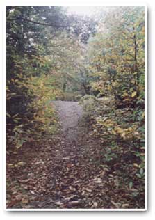
Part of the bank around 'Caesars Camp' in Scholes Coppice.
|
Prehistoric
settlements and other finds
A number of the Heritage Woodlands contain the remains of ancient
settlements, some of which are of national importance. Some
of these, for example the Iron Age fort of Caesar's Camp in Scholes
Coppice, are known to have been fortified, but most were
purely domestic or agricultural in nature. These include those at
Canklow Wood and Wheata
Wood. The first of these is known to have been occupied
over a long period, from the Bronze age (c.1000 BC) to the Roman
age (50-400 AD). At the time when these settlements were in use,
their surroundings are likely to have been cultivated, with nearby
woodland having been exploited for wood and timber as well as for
the grazing of domestic animals. It is unlikely that the immediate
vicinity of these sites was wooded at the time, as the inhabitants
would not want to be vulnerable to attackers approaching them through
woodland.
As well as these major settlements, the Heritage Woods have yielded a number of smaller finds, including two prehistoric flint scrapers in Lees Hall Wood; the remains of a Bronze Age axe or hammer in Woolley Wood ; and a lead weight of Medieval age in Treeton Wood. Close to the summit of Hail Mary Hill within Hail Mary Hill Wood is an archaeological site dating from the Mesolithic (Middle Stone Age) period, where the raw materials, chert and flint, were fashioned into 'tools' used for a variety of purposes.
|
|
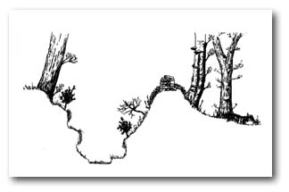
Cross
section of a bank and ditch protecting a coppice woodland.
Reproduced with permission from Rotherham's Woodland Heritage
by Mel Jones and Bob Warburton (Rotherwood Press, 1995)
|
Features associated with woodland management
Archaeological surveys have revealed a large number of features relating to the past management of the woodlands.
Some of these relate to historic woodland boundaries and include woodbanks, often with associated ditches and sometimes topped by the remains of drystone walls. These features, which vary widely in dimension, were constructed in order to keep out grazing animals, which if they had gained access to the woodlands, would have damaged growing coppice and other young trees. Some remains of woodbanks also occur within the woodlands, where they are thought to have been used to separate coppice compartments. At least some of these woodbanks are thought to be medieval in age and they can be a significant feature when deciding whether or not a woodland is of ancient origin. The bank on the north edge of Buck Wood in the Gleadless Valley is particularly important, having formed part of the boundary to the medieval Sheffield deer park.
Particularly significant features associated with past woodland management are charcoal burning platforms, these being the remains of the hearths used in charcoal production.
Whitecoal, a material somewhat similar to charcoal but used
in lead smelting rather than iron and steel production is also known
to have been produced within some of the Heritage Woodlands, in
particular those in the Gleadless Valley. Evidence for this
comes from the presence of characteristically shaped whitecoal pits,
also known as Q-pits because of their shape. Related to these
are dammed ponds, considered likely to have been used to soak the
timber bases on which whitecoal was produced.
|
|
Cross
section of a bank and ditch protecting a coppice woodland.
Reproduced with permission from Rotherham's Woodland Heritage
by Mel Jones and Bob Warburton (Rotherwood Press, 1995)
|
Features associated with
other uses of the woodlands
The large number of quarries, pits, hollows and low mounds found
within the woodlands are very often associated with the search for
coal, other minerals and stone. Some sites, for example Bray
Plantation and Thorncliffe
Wood have prominent bell pits, formed from the spoil
associated with shallow coal mining. In some of the woods, for example
Bowden Housteads Wood can
be found capstones associated with the airshafts of disused coalmines.
Many of the Heritage Woodlands have been found to contain trackways,
together with associated features such as old footbridges. Those
in Wheata Wood are of particular
significance as they date from the medieval period and include 'The
Burying Way' which ran from the medieval settlement of Stanfield
Ash to Ecclesfield Parish Church.
One of the most remarkable features found in recent archaeological
survey work are areas of medieval ridge and furrow which
clearly indicate that these parts of the woodlands have not been
continuously wooded. Sites at which evidence of ridge and furrow
is found include Bowden Housteads
Wood and The Lumb.
|
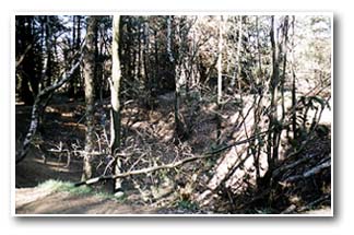
This
crater in Wheata Wood was created when a
bomb landed in the woodland during World War 2.
|
Modern features
Although many of the features described above date back to at least
the medieval period, the woodlands also contain archaeological features
of more modern origin. These include the bases of buildings and
a Second World War bomb crater in Wheata
Wood. The long, flat grassy strip that bisects Cliffe
Wood lies on the route of a disused section of the Barnsley
Canal.
  
|