CANKLOW
WOOD - A SHORT TRAIL
 |
|
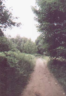
The
main path leading into Canklow Wood from Boston Park
|
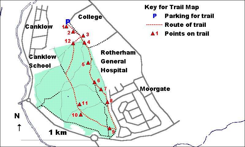
The starting point for
this trail is the parking area next to Boston Castle. This can be
reached along Boston Castle Grove, off Moorgate.
The trail is
just under 3.5 kilometres (2 miles) long. As some parts are along
relatively narrow and steeply sloping paths, it is not suitable
for people in wheelchairs.
The route of
the trail is shown on the map below.
1. Boston Castle is
a former shooting lodge built in 1775 by the Earl of Effingham.
Its name celebrates the Boston Tea Party, the Earl having supported
the struggle of the American colonialists against the British Crown.
Despite its history and its prominent position, the building is
currently derelict, having suffered badly from vandalism.
The grassy area
in front of Boston Castle provides an excellent viewpoint over the
Rother Valley with its steelworks and down the Don Valley past the
Magna Centre, Tinsley Viaduct and Meadowhall towards the centre
of Sheffield. To the north (right) can be seen the follies of Keppel's
Column and Hoober Stand on the Wentworth estate.
A plaque indicates
the direction of a variety of places of interest, both nearby and
further afield.
From the
car park, follow the lower tarmac path through Boston Park.
2. Boston Park
was laid out in 1875 as Rotherham's first public park. A major feature
of the part of the park you are presently in is the face of an old
quarry. The rock here is a sandstone known as Rotherham or Mexborough
Red Rock. This was extensively quarried in the area and can be seen
in use in a number of Rotherham's buildings, including the Parish
Church. In the rock face can be seen cross-bedding which results
from the way in which the rock was laid down on the edge of a shallow
sea.
Set into the
rockface is the doorway from Jesus College, founded by Thomas Rotherham
in 1483.
Continue
past the rockface and up the steps under trees.
3. To your left
are situated a Yorkshire Water reservoir and a communications mast.
Both are located here because this is the summit of the hill.
Continue
along the path into Canklow Wood itself.
4. Note the
range of trees and shrubs along the path. These include Elder, Sycamore,
Oak, Ash, Apple, Birch and Sweet Chestnut. Note how despite this
area being called Canklow Wood, not all of the area is covered in
trees, open areas dominated by Bracken and grasses being very typical
of the upper parts of the site.
Where the
path divides, take the right fork.
5. To the right
of the path is an area occupied by old quarries. As there are no
sheer faces in this area, this is a good place to observe the way
in which these have been colonised by vegetation. More open areas
are dominated by a mosaic of Bracken and grass with Foxglove and
Rosebay Willowherb prominent in the summer months. Other areas have
been colonised by trees, mainly
Birch but with some Oak. As it spreads rapidly, Birch is typically
the first tree species to invade formerly open areas.
At the open
area by the old quarry, fork left along the main path and away from
the quarry edge. Continue through an area of open woodland to another
open area with further quarries to the right. The quarry edge here
is high and unfenced so keep to the left of the area and away from
the cliff edge.
6. In the centre
of the open area is a fine example of a multi-stemmed Oak tree.
Examples of similar trees can be seen across much of the site.
This hilltop
area was previously occupied by a settlement dating from the Bronze
Age and which is now indicated by an extensive system of low earthworks
which are the remains of domestic enclosures, field systems, boundaries
and tracks. Despite its strong defensive position, there is no evidence
to suggest that the settlement was ever fortified.
Continue
beyond the Oak for about 50 metres and take the left fork away from
the quarry edge. Where the path forks again, keep straight on.
7. Here the
path passes through an open area currently dominated by Bracken
but being invaded by young Oaks and Birches. Rabbit droppings on
the ground show that this process is being held at least partially
at bay by grazing.
Continue
along the path, keeping going where the path narrows between trees
and begins to drop downhill. At the point where another path crosses
at right angles (indicated by a waymarking post), carry straight
on, continuing to drop downhill through a mixture of woodland and
more open areas. Shortly after this, houses should become visible
to the left as the path nears the edge of the wood.
Where an
access path enters the woodland from between houses, continue along
the path within the woodland, parallel to the woodland edge.
8. Having so
far been in areas with a mixture of open ground and scattered trees,
you have now entered a more established area of woodland. This is
dominated by Oak rather than Birch and the trees are significantly
older than most of those seen so far. The tree canopy is also more
closed and and there is more Bramble and Holly and less Bracken
on the ground.
As you continue
along the woodland edge, notice how the edge of the wood is used
by adjacent houses for the dumping of garden refuse. Just to the
right of the path, Honeysuckle can be seen climbing vigorously up
a Birch tree.
Do not continue
all of the way to the southern tip of the woodland but instead take
the path off to the right and away from the edge of the wood.
9. This woodland
area towards the southern tip of the site contains the oldest trees
in Canklow Wood. However, because of the past management of the
site, none of the trees are particularly old and many of them are
stunted or twisted. Under the Oak canopy can be found a very limited
shrub layer of scattered Hazel and Holly. The ground flora here
is dominated by grasses, including Wavy-hair Grass and Creeping
Soft-grass. Bracken and Bramble also occur in some areas, particularly
where there are pockets of deeper soil.
Look out for
nest holes and bracket fungi. Nest holes are generally found in
older Oaks whereas bracket fungi occur on dying and often broken
Birches.
Continue
along the path, keeping roughly parallel to West Bawtry Road, further
downslope. Ignore paths off to the right and left.
10. Here the
woodland begins to thin out again and there are fewer Oaks and more
tall, thin 'pole stage' Birches.
Continue
along the path though decreasingly dense woodland.
11. The path
emerges from the woodland into an open area with a mosaic of acid
grassland, Bracken and occasional patches of Heather. Some of this
area was grazed until relatively recently but following the ending
of this, the area is being colonised by young trees, mainly Birches.
Once in this
open area, follow the path slightly round to the right and gently
uphill. Where the path meets a larger track, follow this uphill,
diagonally to the right and in the direction of the communication
mast. Ignore paths off to the left and right. Where the path narrows,
keep straight on up the hill into an area dominated by young Birch
together with some Oak.
12. Here the
path passes through an old hedge on the edge of the site, composed
of a mixture of Hawthorn, Elder and Holly.
Once through
the hedge and into an area of open grassland, climb the path towards
the reservoir to the left of the communication mast. At the top
of the hill, turn left down the steps into Boston Park. Retrace
your route back through the park to the parking area near Boston
Castle.
  
|