|
BOWDEN HOUSTEADS
WOOD - THE SITE
GEOLOGY
Underlying the wood are layers of sandstone, coal seams, shales, siltstones
and mudstones. These all form part of the Middle Coal Measures which were
produced 280 to 350 million years ago during the Upper Carboniferous period
of geological history.
LANDSCAPE
The northern and southern parts
of Bowden Housteads Wood slope gently downhill from the south-east to
north-west. The altitude of the site ranges from 75 metres to 125 metres
above sea level. The adjoining areas of Spring Wood and Car Brook Ravine
lie along a narrow, steep sided valley.
The Car Brook, which
flows from south to north on the western edge of the woodland, is the
main watercourse. This has a number of smaller tributaries which flow
through the woodland from a south-east to north-west direction. Many of
these smaller streams are often dry, especially in summer and after periods
of dry weather. Their beds do however show clear evidence of the accelerated
erosion which occurs during and after wet weather when normal rainfall
is added to by run-off from the impervious tarmac of the Sheffield Parkway
and other roads.
 |
|
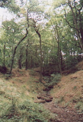
As well as the Car Brook, a number of smaller streams run through
parts of the wood.
This one, in the northern part of the wood shows evidence of accelerated
erosion occuring as a result of runoff from the Sheffield Parkway.
|
SOILS
The soils of Bowden
Housteads Wood are brown earths, some of which are acidic. Most of the
soils are relatively dry although wetter areas occur in association with
the streams, particularly in the Willow-dominated area in the north of
the site.
VIEWPOINTS
The main viewpoints over the
woodland are from:
- pedestrian bridges
crossing the Sheffield Parkway and Mosborough Parkway.
- the public open
space close to Bowden Wood Crescent on the north side of Sheffield Parkway.
- Car Brook Manor
recreation ground and parts of Spring Wood to the south of the Sheffield
Parkway.
As well as views across
the wood, most of these viewpoints also give a clear view across the Lower
Don Valley, taking in such features as steelworks, the Don Valley Stadium,
Meadowhall, the Tinsley cooling towers and the area of Tinsley Park where
opencast coal mining is currently taking place. Beyond the valley of the
River Don can be seen Wincobank Hill.
  
|

