|
| ||||||||||
| | |||||||||
THE GLEADLESS
VALLEY Although the nearby Arbourthorne estates were built in the 1930s, the Gleadless Valley continued to be farmed until the 1950s, retaining a rural landscape of hedge-lined fields, woodlands and scattered farms. Urban development of the valley began in the late 1950's and continued into the 1960's, with the valley's housing estates being built to accommodate approximately 17,000 people. This development was remarkable for the way in which a network of open spaces based around the valley's existing mature woodlands was retained, both within the development, and between it and neighbouring built up areas. Most of these open areas have remained to the present day. The
Meers Brook, which flows through the northern part of Carr Wood, is of
historical importance as it once formed part of the boundary between the
Anglo-Saxon kingdoms of Mercia and Northumbria. The name of the river
dates from this time, 'Meer' being the Saxon word for boundary. The river
continued to form part of the county boundary between Yorkshire and Derbyshire
until as late as 1933.
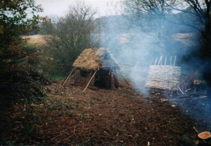
ARCHAEOLOGY Whitecoal,
a material somewhat similar to charcoal but used in lead smelting rather
than iron and steel production is also known to have been produced. Evidence
for this comes from the the presence of whitecoal pits (also known as
Q-pits because of their shape). In addition, there
is an old dam wall in Carr Wood, thought to be the remains of a pond used
to soak the wooden bases used in the manufacture of whitecoal for lead
smelting. ANCIENT WOODLAND
STATUS The earliest known documentary evidence for woodlands in the Gleadless Valley dates from 1462 and refers to 'Herdyng Wood', the name given to the then more extensive area of woodland now split up to produce the two woodland areas of Herdings Wood and Rollestone Wood and The Lumb. The earliest written record for Carr Wood is in a sales document dating from 1583, clearly making it an ancient woodland. Woodland names also provide clues to the ancient origin of Carr Wood, 'carr' being an old Norse word for a damp, riverside woodland. Although no documentary evidence exists for Ashes and Coneygree Woods, their flora, shape, boundaries, archaeological features and terrain strongly suggest that they too are ancient woodlands. The shape and location of ancient woodlands often indicates the way in which previously wooded areas were gradually taken into agricultural production, leaving those woodlands that still remain on ground unsuitable for agriculture because of its terrain. Carr, Ashes & Coneygree Woods exhibit this well, being situated in relatively steep-sided stream valleys. Another way in which ancient woodlands can be distinguished from more recently established woodlands is their diverse flora and fauna. Indeed, certain plant species, usually those that spread relatively slowly by vegetative means, are known to be either entirely restricted to, or only rarely found outside, ancient woodlands. These are known as 'ancient woodland indicator species'. Where a number of these species are found together, there is a high likelihood that the wood in which they occur is of ancient origin. A wide range of ancient woodland indicator species occur in woodlands in the Gleadless Valley, including Bluebell, Dog's Mercury, Ramsons, Wood Anemone, Wood Sorrel and Yellow Archangel. WOODLAND MANAGEMENT Parts of Ashes Wood
are known to have been felled in the 1940's to provide the timber required
during the Second World War and these areas now have a canopy of young
Oaks. The name of Coneygree Wood derives from 'coninger' meaning rabbit warren but the age of this name is not known. FURTHER
INFORMATION
|