|
WHEATA WOOD, PRIOR
ROYD & BIRKIN ROYD - THE SITE
GEOLOGY
The three woodlands lie on bands of Lower Coal Measures sandstones dating
from the Carboniferous period of geological history. At the lower end
of Birkin Royd is a rock outcrop of particular geological interest, where
impressions of prehistoric plants have been found in the sandstone.
LANDSCAPE
The woodlands lie on the top
and westerly facing slopes of an escarpment, which overlooks the valley
of the River Don. The
three woodlands as a whole span a range of 150 metres in altitude, from
very exposed ridge tops to a gorge-like stream course.
Wheata Wood is the
highest of the three woodlands, reaching a maximum height of 300 metres
above sea level. Many parts of the wood are almost flat although others
slope slightly, mainly in a south-easterly direction.
The eastern edge of
Prior Royd is also relatively flat. However, the majority of this woodland
lies on the upper slopes of the Don Valley and as a result slopes quite
steeply towards the west.
Birkin Royd occupies an extremely steep slope above the Sough Dike, the
lowest point being at only 150 metres above sea level.
SOILS
The soils on
which the woodlands are based are mainly acidic and poor in nutrients.
Most of Wheata Wood has free-draining sandy soils, although there are
two seasonally wet areas. The soils of Prior Royd are also generally free-draining
although there is a line of springs, which feed a complex of small watercourses
running into Sough Dike. There are also a number of wet nutrient-rich
areas, known as flushes, on the steep slopes of Birkin Royd.
 |
|
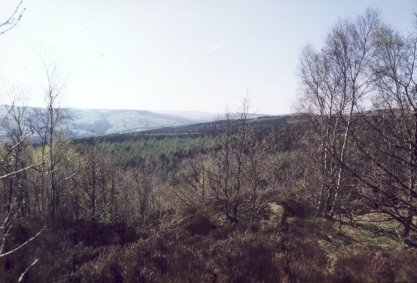
This clearing
in the centre of Prior Royd provides an attractive view of the Upper
Don Valley and of the moorlands above and beyond Stocksbridge.
|
VIEWPOINTS
Looking north-westwards from
the short section of path between fields that connects the northern limb
of Wheata Wood with the upper part of Prior Royd provides a clear view
of a range of semi-natural and man-made vegetation types, including broadleaved
woodland, coniferous forest, pasture, meadow, heathland and high moorlands.
A clearing in the
centre of Prior Royd provides an excellent view south-westwards to Oughtibridge
(in the valley bottom) and Worral (on the hill above). To the north-west
can be seen the mixed conifer plantations of Wharncliffe Woods.
Points along the south-western
edge of Prior Royd also give views into and beyond the Don Valley. The
steeply sloping southern edge of this woodland provides clear views of
the centre and north-western parts of Sheffield as well as to the eastern
moorlands of the Peak District beyond. The south-east corner of this wood,
on the other hand, provides views in the opposite direction, taking in
parts of northern Sheffield,and, beyond the M1 motorway, of the Rotherham
area.
  
|

