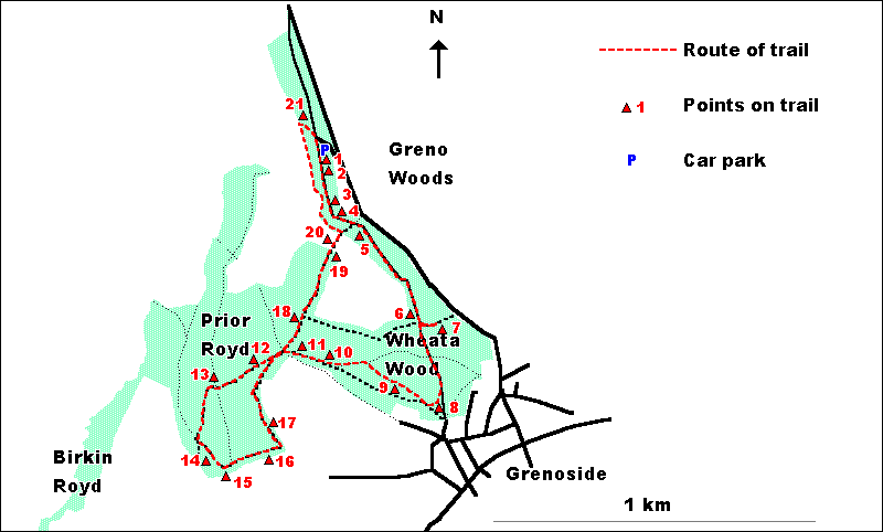
WHEATA WOOD,
PRIOR ROYD & BIRKIN ROYD -
A SHORT TRAIL
Two versions of this
trail can be followed, depending on the age and enthusiasm of those
involved.
The shorter
version of the trail, which is restricted to Wheata Wood and the
flat upper parts of Prior Royd, is 2.5 kilometres ( 1.5 miles) long.
Most of the paths on this section are broad, well-maintained and
more or less flat.
For those wishing
to follow a longer route, an extension to the trail taking in lower
parts of Prior Royd is provided. The length of this full trail is
3.6 kilometres ( just over 2.25 miles). This longer version of the
trail does include some narrower paths and a relatively steep uphill
section in the lower part of Prior Royd.
The starting
point for both versions of the trail is the car park in the northern
end of Wheata Wood which is reached off Woodhead Road. The trail
can also be joined at a number of other points where it comes close
to or crosses the perimeter of the site, in particular at the 'wood-yard'
(point 8 on the trail), which is close to the pedestrian access
from Grenoside village.
The trail route
is illustrated on the map below.
Leave the car park
through the gap in the fence leading onto the bridleway.
1. This is part
of the Trans-Pennine Trail, a coast-to-coast network of paths running
from Liverpool to Hull and ultimately connecting with paths across
Europe which lead all of the way to Istanbul. The Trail has been
built to be suitable for a wide variety of users, including walkers,
cyclists, horseriders and people with disabilities.
The west-facing
bank to the right of the path has a number of different tree species
including Beech, Oak, Birch and Holly.
Turn left
and follow the Trans-Pennine Trail southwards.
2. This is at
the northern end of a narrow strip of woodland with fields on either
side. The field to the left shows clearly how areas have been cut
out of the woodland in a piecemeal fashion for agricultural use.
Continue
southwards along the Trans-Pennine Trail.
3. On the far
side of a small stream is an area with a richer ground flora than
previously encountered. This is because the soil here is wetter
and richer in nutrients. Look out for Honeysuckle around the base
of trees, as well as for clumps of ferns.
Continue
southwards along the Trans-Pennine Trail.
4. This area
is dominated by tall, straight Beech trees. Look at the way in which
the heavy shade cast by the Beech suppresses the ground flora and
makes it very sparse. Look for Beechnuts or their cases on the ground.
Continue
southwards along the Trans-Pennine Trail.
5. As you continue
to move southwards, look out for the knobbly trunks of Sweet Chestnut
trees. This area also has many large Holly bushes. Look out too
for the old tree stump on the right hand side of the path that has
been colonised by Bilberry, showing that the soil here is acid.
Continue
southwards along the Trans-Pennine Trail.
6. To the right
of the path, just before the place where the paths cross, is an
area of damp soil that supports the best area of ground flora in
Wheata Wood. Take care not to trample this area but look for different
flowers, which include Lesser Celandine, Wood Anemone and Ramsons
(also known as Wild Garlic), and also for the butterflies and bees
that visit this area on a sunny day.
At the crossing of the paths, turn left towards the road.
7. The area
to the right of this track has been thinned in the past few years.
Some of the lower parts of tree trunks have been left standing and
small branches have been left on the ground because they provide
an important feeding and nesting habitat for birds and insects.
Do not
continue along the track to the road but instead return to the crossing
of the paths and turn southwards along the Trans-Pennine Trail.
8. This open
area was once a wood-yard when Wheata Wood was managed for commercial
forestry. This location was chosen because it is close to the village
and easily accessible.
At the
wood yard, turn right but instead of taking the bridlepath along
the edge of the wood, take the smaller path through the gap in the
fence.
9. In this area
of woodland, find somewhere to sit quietly for a few minutes. How
many different kinds of birds and animals can you see and hear?
Continue
along the small path through the trees.
10. This large
hole in the ground is a bomb crater formed by a stray bomb on the
night of the Sheffield Blitz. The trees around the crater are Corsican
and Lodgepole Pines - planted, non-native conifers.
From the
bomb crater, cut diagonally left across to a small area of heath
on the edge of the wood.
11. This small
area of heathland between Wheata Wood and Prior Royd was once much
more extensive. The main plant growing here is Heather, this being
accompanied by smaller amounts of Bilberry. Both of these species
are typical of heathlands on dry, acid soils.
Note the way
in which this open area is continuing to be invaded by trees of
Birch and, to a lesser extent, of Oak.
Go forward,
ignoring the stiles into the adjacent field, and enter Prior Royd.
Where the paths cross:
- continue
down the hill along the path if following the full trail
- turn
right, through the barrier, if taking the shorter route and pick
up the trail descriptions at point 18.
A compromise
would be to follow the full route to the viewpoint (point 13) and
then retrace your steps back to this point.
12. As you walk
downhill through Prior Royd, compare the woodland to that in the
majority of Wheata Wood. The trees are generally much younger and
closer together and the ground flora is more consistently heathy.
Look out for 'bracket' fungi on old birch trunks.
Continue
downhill along the broad path.
13. This area
of heathland (which, like that seen previously, is becoming invaded
by trees) is associated with an area of old quarries. It provides
an excellent view south-westwards to Oughtibridge (in the valley
bottom) and Worral (on the hill above this). The line of pylons
in the valley bottom provides the power supply for the Stocksbridge
steel works. The view to the north-west looks across to the mixed
conifer plantations of Wharncliffe Woods.
Continue
down the path. At its junction with another main path, turn left
and take the path slightly uphill. Do not take the lower, wider
path to Hunter House Farm.
14. The path
passes just above an area dominated by Holly. These 'holly haggs'
were used to provide winter fodder for cattle and may be associated
with nearby Hunter House Farm.
Continue
until you reach the wall and pause to look at the view from the
woodland edge.
15. The view
southwards from this edge of the wood takes in the tower blocks
of Stannington, the suburb of Crosspool on the hill and looks towards
the edge of the Peak District.
Do not
go through the stile into the fields but instead, follow the narrow
path uphill inside the wood.
16. After climbing
steeply, the path heads through the middle of another area of Holly.
At the top of the slope, look east across the fields towards Rotherham.
Can you spot the M1 motorway and the two old cooling towers at Tinsley?
Do not
go through the stile into the field but instead turn left and follow
the path parallel to the wall.
17. This section
of path is often churned up by mountain bikes and can be muddy providing
an illustration of conflicts between the activities of different
woodland users.
At the
crossing of the paths, keep straight on through the barrier.
18. Watch out
for a large multi-stemmed Oak tree to the left of the path. This
could well be a relict of the time when these woods were intensively
managed for charcoal production by coppicing.
Continue
along the broad, flat path.
19. Just before
you reach the fields, look for Witches' Brooms in the Birches. These
are caused by a micro-organism which lives in the branches of the
trees.
Go through
the stile and take the path between two walls that links Prior Royd
with Wheata Wood.
20. The path
between the two woods provides another good viewpoint. To the south
can be seen an area of agricultural land which must once have been
part of the woodlands. A variety of different land uses can be seen
to the north, including farmland, the commercial forestry area of
Wharncliffe Wood, and the high, rocky area of Wharncliffe Heath.
In the far distance are the moorlands which lie above and beyond
Stocksbridge.
Turn left
on entering Wheata Wood and take the path alongside the wall. Continue
along the path roughly parallel to the wall. At the end of this,
turn right and follow the wide track uphill towards the car park.
21. This is
an important access track to the commercial forestry area of Wharncliffe
Woods. The bank to the left of the track provides a cross section
of the thin, stony acid soils underlying this part of Wheata Wood.
Continue
up the track to the car park and the end of the trail.
  
|