|
GIBBING GREAVE
& HERRINGTHORPE WOODS - THE SITE
GEOLOGY
The rocks underlying the two
woodlands date from the Carboniferous period of geological history and
belong to the Upper Coal Measures .
As a rule, the upper
slopes of each wood are occupied by sandstones, with softer shales outcropping
on the steep valley sides and in the valley bottoms.
In the western part
of Gibbing Greave, these rocks are, at least partly covered by boulder
clay dating from the Ice Age.
|
|
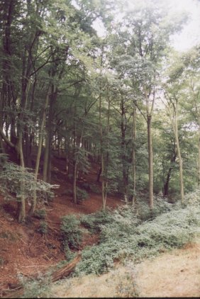
The
interior of Gibbing Greave, looking south-westwards across the
stream to the
Beech
plantation.
|
LANDSCAPE
The
woodlands occupy the valley bottoms and steeply sloping sides of two stream
valleys. A small
un-named stream runs east to west through Gibbing Greave and on the southern
side of this, in the centre of the wood, there are a number of springs.
The southern edge of Herringthorpe Wood is formed by Herringthorpe Beck,
which has its source on the southern edge of the woodland.
The altitude of Gibbing
Greave ranges from just under 60 metres above sea level, where the stream
leaves the western edge of the wood to just over 90 metres at the south-east
corner of the wood. Herringthorpe Wood ranges in altitude from around
50 metres where Herringthorpe Beck leaves its northern tip, to approximately
90 metres on its north-eastern edge.
SOILS
Most of the soils underlying
the woodlands are thin, moderately acid (pH 4 to 6), and free draining.
This easy drainage combined with the influence of the steep slopes and
the fact that many of the plantation areas are characterised by bare soil
has led to nutrients being leached from the soil. In addition, some of
these areas of bare soil are currently affected by soil erosion.
Along streams the soils
are wetter and less acid (pH 6 to 6.5). The ground in the area of Alder
carr to the north of Herringthorpe Wood is particularly marshy.
VIEWPOINTS
The two woodlands are prominent
features of the local landscape and also offer fine views of the surrounding
countryside.
The best views across the surrounding area can be obtained from the point
where the two woodlands meet, on the upper edge of Herringthorpe Valley
Park. From here can be seen Keppel's Column, the spire of Wentworth church
and Hoober Stand; three features associated with the Wentworth Woodhouse
estate. In addition there are more general views across Rotherham and
the valley of the River Don.
  
|

