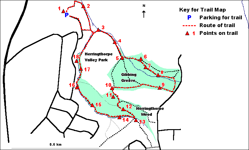
GIBBING
GREAVE & HERRINGTHORPE WOODS - A SHORT TRAIL
|
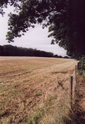
View
from the southern edge of Gibbing Greave across a field to
the northern edge of
Herringthorpe Wood.
|
The starting point for
this trail is the car park in Herringthorpe Valley Park. Alternatively,
the trail could be joined from the either of the two access points
into Gibbing Greave from Brecks Lane (between points 8 and 9 on
the trail); from the bridge into Herringthorpe Wood from Great Bank,
adjacent to the 'Crocodile and Clock' sculpture (point 13 on the
trail); or at the entrance from Brookside (point 16 on the trail).
The trail is
just over 2.5 kilometres (1.5 miles) long and is straightforward
to follow. Although most of the trail is on easy paths, parts are
on moderately steep slopes and other areas, particularly along the
streamside in Herringthorpe Wood, can be muddy.
The trail route
is illustrated on the trail map below.
1. From the car park can
be seen a patchwork of fields separated by overgrown hedges, many
of which are of value as a wildlife habitat. This landscape is a
relict of the time at which this was a predominantly agricultural
area.
Follow
the path at the far corner of the car park from the access road
down into the valley, with tennis courts on your left. At the bottom,
turn right up the valley.
2. The stream
to your left is Herringthorpe Beck which starts in Herringthorpe
Wood and is joined by a stream flowing through Gibbing Greave. Associated
with the stream are Alder and a variety of Willow species. On the
far side is a hedge composed of Hawthorn.
Continue
along the path, go through the gate, cross the stream and turn left.
3. To the left
of the path can be seen the confluence (joining point) of the streams
flowing through the two woods.
Follow
the path towards the edge of Gibbing Greave with the stream to the
left.
4. The streamside
here supports a wide variety of tree and shrub species, including
Oak, Hawthorn, Willow, Elder, Hazel, Alder, Birch, Sweet Chestnut,
Sycamore, Ash and Hybrid Black Poplar. Of these, the last two are
represented by some particularly tall trees. In late summer and
early autumn, look for Hawthorn and Elder berries and 'seed cones'
of Alder.
Continue
along the path and enter the woodland of Gibbing Greave. Ignore
the eroded path to the left immediately inside the wood, continuing
a short way to the top of the steps which descend to cross the stream.
5. This point
provides a clear view into the interior of the woodland, showing
a dense tree canopy with very few shrubs beneath. The trees in the
foreground are largely Oaks, with planted Beeches being dominant
beyond. Note that because the tree canopy here casts too much shade,
there is little in the way of regeneration (regrowth of young trees)
except in some patches where gaps in the canopy have let in light.
Turn down
the steps and cross the bridge over the stream. Follow the path
uphill with the stream to your right.
6. This glade
has been opened up in a formerly wooded area cleared to let in light
and encourage the growth of young trees. Notice the way in which
young trees of Beech, Oak, Birch and Willow have begun to grow prolifically
on the edges of the glade. The lower parts of a number of dead trees
have been left standing as these support a wide variety of wildlife
including fungi, insects and hole nesting birds.
The path
that you have been following divides just below the glade. Retrace
your steps a short way to the path junction and take the right hand
(lower) path.
7. You have
now entered the area of Gibbing Greave with the most 'natural' vegetation.
Oak is the most common tree here and beneath it is a relatively
dense shrub layer of Holly and Bramble. Although this is the most
natural area of woodland, this area has, over a long period of time,
been influenced by woodland management and as a result it is said
to be 'semi-natural'. This means that it displays something of its
original character and species composition whilst having been modified
by human activity.
Continue
along the path.
8. This is an
excellent point from which to compare the semi-natural Oak-dominated
woodland on this side of the stream, with its dense shrub layer
and rich ground flora; and the Beech plantation on the far side,
which has much bare ground and little in the way of a shrub layer.
These differences result from the way in which the dense Beech canopy
lets through much less light than that of the semi-natural woodland.
Continue
along the path, taking care as there is a moderately steep slope
down to the stream. Just before you reach the edge of the wood,
turn right across the small plank bridge over the (often dry) stream
channel. Before reaching the gate, turn right through the upper
parts of the Beech plantation.
9. Here you
can see, at close hand, the way in which the Beech-dominated plantations
support very little in the way of either a shrub layer or ground
flora. Instead there are substantial areas of bare soil. Note the
way in which more light is able to gain access at the woodland edge
where as a result there is a better developed shrub layer and a
richer ground flora. Look for the seed cases of Beech seeds (known
as beech mast) on the ground.
Continue
along the path through the upper part of the Beech plantation. Where
the path divides, keep left on the upper path, parallel to the woodland
edge. On reaching the far edge of the woodland, turn left through
a gap into the upper edge of Herringthorpe Wood.
10. The point
where the two woods meet provides a view across the upper parts
of Herringthorpe Valley Park. For a better view, leave the woodland
edge and cross an area of mown grass to the far edge of a group
of planted willows. However, do not go further than this onto the
pitch and putt course.
This point provides a view across Rotherham, situated in the valley
of the River Don, and in the distance takes in three features associated
with the Wentworth Woodhouse estate, these being (from left to right)
Keppel's Column, the spire of Wentworth church and the folly of
Hoober Stand.
Take the
main path down into Herringthorpe Wood, rather than the one leading
to the left along the field boundary.
11. The woodland
area to the right of the path is relatively young in comparison
to those on the rest of the site, being only 15 to 20 years old
and having developed on an area that was previously grassland. Sycamore
and Oak are the dominant tree species, along with smaller quantities
of Hawthorn, Silver Birch, Elder, Ash, Crab Apple and Crack Willow.
Continue
down the path, keeping straight on at the path junction.
12. You have
now entered another plantation area. This is somewhat more mixed
than that in Gibbing Greave and as well as Beech has a significant
quantity of Sweet chestnut and Oak. Despite this, a shrub layer
is again largely absent and the ground is still generally bare.
Continue
down the path towards the bridge. Cross the bridge over the Herringthorpe
Beck.
13. This side
of the stream is not strictly part of Herringthorpe Wood, being
instead on the edge of Great Bank , an area of grassland, scrub,
young woodland and old quarries. The feature close to the bridge
is the 'Crocodile and Clock' a piece of environmental art created
by an artist working in conjunction with local teenagers
Recross
the bridge and take a path (at first, rather indistinct) along the
streamside.
14. Note the
way in which the Herringthorpe Beck has cut into its bed and banks
at times of high flow.
Continue
along the path, with the stream to your left. Do not cross the first
bridge but keep on, still with the stream to your left. Take care
here, particularly after wet weather, as the path which is on a
bank above the stream can be muddy.
15. This is
an area of streamside woodland which, unlike the plantation area
above, supports a wide variety of trees and shrubs including Sycamore,
Ash, Hazel, Beech, Elder, Birch, Oak, Hawthorn, Rowan and tall trees
of Hybrid Black Poplar.
Carry
on along the path with the stream on your left, continuing to take
care on areas of muddy ground. Just past the end of the houses on
the far bank of the stream, cross the bridge over the stream to
the gate.
16. This gate
is another example of environmental art, this time designed and
carved by a local artist. The rabbit on the gate post is easy to
spot. Look also for the carved leaf shapes and the animal tracks.
Recross
the bridge and turn left along the stream. Keep on along the stream
into the narrow strip of woodland, continuing to take care on areas
of wet and muddy ground. Follow the path onto the boardwalk, taking
care as this can be slippery when wet.
17. Here the
marshy area along the stream is occupied by wet Alder-dominated
woodland, known as alder carr. As well as alder, other tree and
shrub species in this area include Sycamore, Hazel, Elder and Hawthorn.
The ground flora is lush and includes Nettle, Dog's Mercury, Bittersweet,
Great Willowherb and Buttercup. Note the way in which Beech, Sycamore,
Sweet Chestnut and Oak become dominant on higher ground on the edge
of the woodland.
At the end of the boardwalk, continue along the path.
18. At this
point, on the far side of the stream, can be seen an open marshy
area with wetland vegetation dominated by Reed Sweet-grass and Greater
Willowherb.
Leave
the woodland at its far end and turn left along the surfaced path.
Turn left at the path junction and through the gate. Turn left again
up the path under a line of trees. At the top, turn right and follow
the access road back to the car park.
  
|