|
SCHOLES COPPICE & BRAY PLANTATION
- VISITING THE WOODS
LOCATION
Description
Scholes Coppice and Bray Plantation are located on the edge of Rotherham,
2.5 miles (4 kilometres) north-west of the town centre. They are situated
between the residential area of Kimberworth Park and the small village
of Scholes, which in turn lies close to the larger settlement of Thorpe
Hesley.
Although the two woodlands
are only a short distance apart, between them lies Keppel's Field, an
unimproved meadow rich in wildflowers which together with the woods forms
a Local Nature Reserve.
On the other side of the A629 road from Scholes Coppice and Bray Plantation
lies Grange Park, which incorporates a number of other Heritage Woodlands,
including Walkworth Wood, Gallery Bottom, and Barber Wood.
 |
|
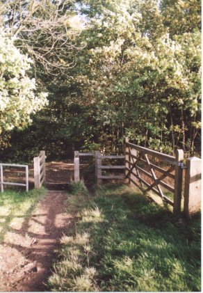
One of the entrances
into Scholes Coppice which leads from the bottom part of Keppel's
Field.
|
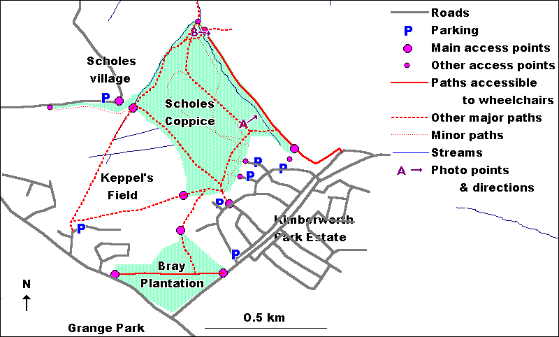
Grid
reference
The grid references of the two woodlands are:
- Scholes Coppice
SK394953
- Bray Plantation
SK392944
The adjacent wildflower-rich
grassland of Keppel's Field lies at grid reference SK391950.
VISITING BY
CAR
Parking
Parking can be found on a number of different roads around the woodlands.
Please refer to the access map below.
Both Scholes Coppice
and Bray Plantation can be easily reached from a part of the Kimberworth
Park housing estate which borders the site. Here parking can be found
on roads including Studmoor Road (the nearest to Bray Plantation) and
Beckett Crescent and the cul-de-sacs of The Coppice, The Willows and Pepper
Close, all of which give easy access to the southern edge of Scholes Coppice.
As these are all residential roads, parking is limited and consideration
should always be given to local residents. In particular, care should
be taken not to park across residents' private drives.
For access to the
north-western corner of Scholes Coppice, a small amount of parking can
be found on Scholes Lane. This is a relatively narrow rural road and care
should be taken not to block it in any way.
Finally, the residential
road of Admirals Crest gives access to Scholes Coppice across Keppel's
Field. Again, consideration must be given to local residents.
Parking on Upper Wortley
Road (A629) and on Oaks Lane leading into the Kimberworth Park estate
is not recommended as both are busy through roads.
PUBLIC TRANSPORT
Buses
The Scholes Coppice area is well served by buses from which leave Rotherham
Transport Interchange in the centre of the town.
Buses up the A629
Upper Wortley Road include the number 16, which runs every half an hour
to Thorpe Hesley, and the number 66, which runs to Chapeltown, also every
half hour. In addition the express bus number X12 runs once every hour.
Also very convenient
for access to the woodlands is the number 8, which runs every 20 minutes
to Beckett Crescent (very close to the southern edge of Scholes Coppice),
via Oaks Lane.
All bus routes and
times are of course subject to change and so you are advised to contact
Traveline on 01709 515151 to confirm these details.
ACCESS TO
THE WOOD
Please refer to the
access map below.
Access Points
Scholes Coppice
The main access points to Scholes Coppice are:
- From the south
Into the southern edge of the wood from roads in the Kimberworth Park
estate, including Town Lane Beckett Crescent, Pepper Close, The Willows,
Studmoor Road and Monk's Close.
- From the west
Along paths leading from Admiral's View across Keppel's Field into the
south-west and north-west corners of the wood.
- From the north
Into the north-western corner of the wood along a narrow path leading
off Scholes Lane in Scholes village, and into the north-eastern corner
of the wood from Cinder Hills and the Wentworth estate.
- From the east
Into the north-eastern corner of the wood via a path leading across
farmland.
Bray Plantation
The main access points to Bray Plantation are from Oaks Lane into the
eastern corner of the wood and from Upper Wortley Road into its western
corner.
 |
|
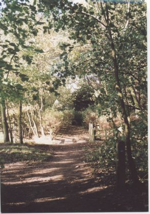
Scholes Coppice
and Bray Plantation are both very accessible, being crossed by a
number of wide, relatively level paths.
|
Paths
Scholes Coppice
Scholes Coppice is well served by footpaths and bridleways, these being
shown on the access map above.
A surfaced bridleway
runs in a circular route around much of the woodland and there is also
good access along the concrete track running along the eastern edge of
the woodland.
A large number of
other footpaths are also present. Because these are unsurfaced, they can
be soft and muddy in wet weather.
Bray Plantation
The main path through Bray Plantation runs in an approximately straight
line between the eastern and western corners of the wood. This is part
of the Trans-Pennine Trail, a network of footpaths across the country
between Liverpool and Hull. Another path runs up the north-eastern edge
of the wood and continues from here, between two areas of housing and
across an area of grassland, to reach the southern edge of Scholes Coppice.
Wheelchair Access
Scholes Coppice
Although much of Scholes Coppice is not currently suitable for people
in wheelchairs, entry to the southern edge of the woodland can be gained
through a new wheelchair access at the entrance point off Studmoor Road.
There is another disabled access stile at the end of The Willows, but
unlike that off Studmoor Road this does not have a lowered pavement kerb
and the ground here is also less firm and dry.
The concrete track running along the eastern edge of the woodland provides
limited wheelchair access.
Bray Plantation
The main track through Bray Plantation is wide and flat and also part
of the Trans-Pennine Trail which has been specifically designed for use
by a wide variety of people, including wheelchair users.
TOILET FACILITIES
There
are no toilets at the site, the nearest such facilities being at the Hook,
Line & Sinker public house on Oaks Lane/Town Lane.
CONTACT INFORMATION
Scholes Coppice &
Bray Plantation are both owned and managed by Rotherham Metropolitan Borough
Council.
For further information,
see Get in Touch elsewhere
on this website.
  
|