|
| ||||||||||
| | |||||||||
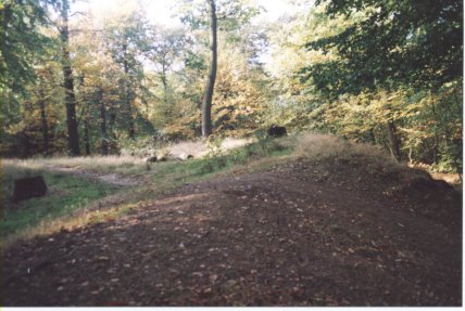
ARCHAEOLOGY Caesar's Camp is to be found in the eastern part of Scholes Coppice. It was surveyed and partially excavated in the early 1990s, at which time the earthen bank around the circumference of the feature was found to range from 2 to 5 metres in height and be in places some 15m wide. This bank was probably constructed in two phases, incorporating layers of stone overlying a base of compressed clay. There is evidence that, at some time, the bank was topped by a wooden palisade (strong fence) surrounding the entire enclosure.
With the bank is associated
an equally impressive external ditch, some 15 metres wide. The absence
of any clearly defined entrance into the monument is a matter of great
interest. As the ditch appears to have been continuous, it is likely that
the entrance into the enclosure would have involved some kind of structure,
most likely a timber bridge or raised timber platform. Caesar's Camp is now designated as a Scheduled Ancient Monument. The other main features of archaeological interest in Scholes Coppice are the woodland boundaries, particularly those on the north-western, southern and south-eastern edges. These are marked by large woodbanks, which in places are still topped by drystone walling. The stone wall along the north-western boundary of the wood coincides with the original boundary of Kimberworth Deer Park (see below). A concrete track which runs along the north-eastern edge of Scholes Coppice is thought to have been constructed to allow the transport of coal from areas adjacent to the woodland that were exploited by opencast mining. Bray Plantation also displays clear evidence of mining for coal and ironstone in the shape of a large number of 5-6 metre high mounds with central depressions. These mark the locations of former 'bell pits' in which a shallow shaft was sunk and the mineral extracted immediately around it. The mineral would have been brought to the surface using a windlass or horse gin. Bell pits were sunk in the local area over a long period, from the eleventh century through to the middle of the nineteenth century. Bell pits can also be found in adjacent areas of open ground. At the top, western
corner of Keppels Field is Keppel's Column, a 115 foot (35 metre) tall
monument, built by the Second Marquis of Rockingham in 1778 to commemorate
the acquittal of this friend Admiral Keppel, who was charged with cowardice.
ANCIENT WOODLAND
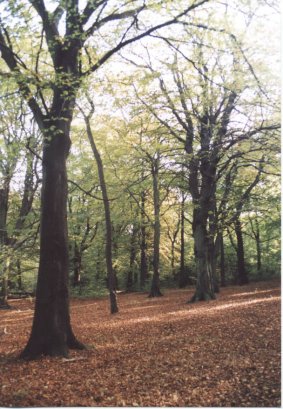
STATUS The location of a wood is another clue, ancient woodlands often being located on the edge of a parish, other areas closer to the village having been cleared for building or agriculture. This is the case at Scholes Coppice, the stream along the eastern edge of the wood being part of the historic parish boundary between Kimberworth and Greasbrough. Scholes Coppice also shares with many known ancient woodlands, a name taken from a nearby settlement, in this case the village of Scholes just to the north. Another way by which ancient woodlands can be distinguished from more recently established woodlands is by their diverse flora and fauna. Indeed, certain plant species, usually those that spread relatively slowly, are known to be either entirely restricted to, or only rarely found outside, ancient woodlands. These are known as 'indicator species'. Where a number of these species are found together, there is a high likelihood that the wood in which they occur is of ancient origin. Seventeen of these ancient woodland indicators have been recorded in the two woods, including Broadleaved Helleborine, Bluebell, Yellow Archangel, Dog's Mercury, Yellow Pimpernel, Wood Anemone, Wood Sorrel, Ramsons, Great Woodrush, Remote Sedge, and the grasses, Wood Millet and Wood Melick.. In contrast to Scholes
Coppice, Bray Plantation is not an ancient woodland, having been planted
sometime in the early years of the 19th century. The Scholes area was also part of the deer park of Kimberworth Park, first mentioned in the 13th century and known to have held deer until at least 1635. Deer parks were areas of private land, bounded by a wall or fence-topped bank in which the owner kept deer but also hares and rabbits, in order to provide his family with a reliable source of meat. As well as more open areas of ground, these parks contained woodland, much of which was coppiced in order to provide a continuous and self-renewing supply of trees. Thus Scholes Coppice and other nearby woodlands were an integral part of the park, being used to supply timber and wood. Historical records suggest that Scholes Coppice has been managed for timber since the 11th century. The presence within the Kimberworth Deer Park of 300 acres of coppice woodlands is recorded in a document written between 1590 and 1616 for the 7th Earl of Shrewsbury. At this time, the woodland extended westwards to cover twice its present-day area, covering what is now Keppel's Field. In the middle of the 17th century, when it ceased to be used as a deer park, the area was let to tenants, in particular to Lionel Copley, a local ironmaster and charcoal maker who continued to coppice the woodlands in order to provide fuel for his furnaces. This continued for a relatively short time, the last record of coppicing in Scholes Coppice being in 1726. This is a relatively early date for coppicing to cease, the practice having continued in other local woodlands until as late as the second half of the nineteenth century. Instead, Scholes Coppice and its surrounding area, having passed from the Duke of Norfolk to the Fitzwilliam family of Wentworth Woodhouse, became part of Wentworth Park. In 1726, Scholes Coppice was recorded as being 'cut into walks for beauty and intended to be thrown in a Park". These wide rides which intersected the woodland can be clearly seen on a map dating from 1791.
The later history of Scholes Coppice is poorly known but it is assumed that the woodland gradually reverted to high forest, and was perhaps managed principally for sport and walking, with timber production being of secondary importance. It is clear from an Ordnance Survey map published in the mid 19th century that the woodland had, by this time, a mixture of broadleaved and coniferous trees. Scholes Coppice has been replanted at least once since this time explaining why the majority of it is now mature woodland about a hundred years old containing a mixture of native and non-native trees. In the 1940s, the
western half and eastern edge of Scholes Coppice was opencast mined for
coal and ironstone. The remaining woodland appears to have been managed
commercially until the early 1960s, for both timber and pheasant shooting. Bray Plantation is first shown on an 1834 map of the Earl of Effingham's estate to which it once belonged. At this time, it formed part of a more extensive woodland linked to Redscope Plantation to the south. The abundant remains of 'bell pits' in Bray Plantation show that the area was heavily exploited for coal and ironstone but that, in contrast to its neighbour, it was not opencasted. In 1981, Scholes Coppice,
along with Keppel's Field, was given to the South Yorkshire County Council
by its former owner, Countess Fitzwilliam of Wentworth. It was subsequently
passed to Rotherham Metropolitan Borough Council. Bray Plantation was
acquired by the council earlier than this, in 1930. FURTHER INFORMATION |