|
SCHOLES
COPPICE & BRAY PLANTATION - EDUCATIONAL USE
INTRODUCTION
Scholes Coppice and Bray Plantation both have considerable potential
for educational use, especially as they are easily accessible and
situated close to a populated area.
More detailed information to support education work in the two woodlands
can be found in the Fuelling a Revolution education pack covering
Scholes Coppice & Bray Plantation. Details on how to obtain
this can be found in the Schools
section of this website.
SUGGESTED
ACTIVITIES FROM THE SCHOOLS SECTION OF THIS WEBSITE
The Schools section of this
website provides units of work covering a wide range of subject
areas and Key Stages. Although, many of these units would be suitable
for use in Scholes Coppice & Bray Plantation, some are particularly
appropriate, and for this reason, direct links to these downloadable
materials are provided below.
Foundation Stage - 'Use
your Senses'
Scholes Coppice is some way from the nearest main road and as a
result is a good location for using the sense of hearing in a woodland
context. There are also plenty of interesting things to see, feel
and smell.
Key Stage 1 Science - 'Plants
& Animals'
This unit could be used to compare the wildlife of the two woodlands
with either your own school grounds or adjacent open areas such
as Keppels Field or the area of grassland between the southern edge
of Scholes Coppice and the Kimberworth estate.
Key Stage 1 Geography- 'Our
Local Wood'
Being situated close to residential areas such as Kimberworth Park
estate, the two woodlands could form part of a route around the
local area looking at different land uses.
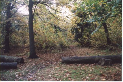 |
|
Take care
on logs such as these. They can be slippery in wet weather.
|
Key
Stage 2 Numeracy - 'Girth
& Gaps'
This unit could be used to compare the spacing and measurements
of trees in different areas of the woodlands. A comparison between
areas of high forest with widely spaced large trees and areas cleared
in the recent past and where there are now dense growths of young
trees would be particularly worthwhile.
Key
Stage 2 Science - 'What
Lives Where?'
The range of vegetation types in and adjacent to
the woodlands provides an excellent resource for studying where
the specified animals find shelter, water and food.
Key Stage 2 Science -'Life
Cycles'
The range of ages of trees on the site makes it ideal for the study
of changes during a tree's life cycle, from seed through sapling
and mature tree to old age, death and decay.
Key
Stage 2 Geography - 'Do
you come here often?'
The two woodlands are popular places for formal and informal recreation,
being used for a wide range of recreational activities, some of
which are acceptable and others of which are less so. Walking is
probably the most common informal activity taking place but other
activities include mountain biking, horse riding, vandalism, natural
history study, environmental education and motor cycling. This unit
could be used to study recreational activities taking place and
to consider potential conflicts between these and possible effects
on the site.
Key Stage 3 Science - 'Woodland
Survival'
Examples of all of the different adaptations to woodland life listed
on the pupil sheet can be found in the two woodlands.
Key Stage 3 Science - 'Are
All Woods the Same?'
This unit of work could be used to compare the fauna and flora of
the semi-natural and plantation areas of the site.
Key Stage 3
Science - 'Tree
of Life'
The dominance of parts of both woodlands by single tree species
makes the site particularly suitable for this unit which looks at
the flora and fauna associated with one tree species.
Key
Stage 3 Geography - 'Woodland
Climates'
Use this unit to compare the climates of the Beech plantation areas
and semi-natural woodland area to adjacent open areas such as Keppel's
Field.
Other activities
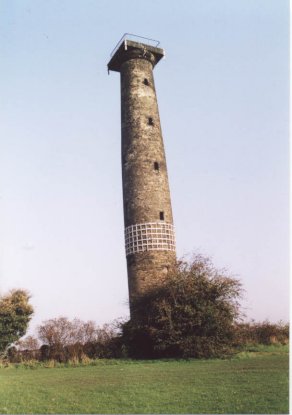 |
|
Keppel's
Column at the top corner of Keppel's Field.
|
Key
Stage 2 History
What was it like to live here in the past?
The changes in use of the area occupied by Scholes
Coppice make it an ideal subject for an enquiry- based local study
incorporating old documents and a field visit. Several periods of
time can be compared, for example:
- The
period after the Ice Age ended when the landscape changed from
tundra to woodland and it may have been used for hunting wild
animals and collecting berries and fruit.
- The
Iron Age when it was in a frontier zone and the woodland was cleared
and Caesar's Camp occupied.
Norman times when the parish of Kimberworth in which Scholes Coppice
lay, was dominated by wood pasture in which animals (such as pigs)
grazed the woodland floor whilst the upper layers of the woodland
were exploited for timber.
- The
medieval period when it was a wood (probably a coppice wood) in
a deer park laid out by the lord of the manor of Kimberworth.
- The
18th and 19th centuries when it became part of the landscaped
park of the aristocratic owners of Wentworth Woodhouse and during
which time the woodland was replanted with a mixture of broadleaved
and coniferous trees.
- The
1940s, when the western half and eastern edge of Scholes Coppice
was opencast mined for coal and ironstone, an area which has since
regrown.
- Public
ownership of the woodland since 1981 and its subsequent use as
a recreational resource and wildlife habitat.
More
details of the history of the Scholes area can be found on the page
of this site which deals with the history and
archaeology of the site. In addition, the animated
interactive provides a general overview of the history of woodlands
such as Scholes Coppice including many of the points listed above.
Key
Stage 3 Science
Study the effect of recent woodland management in Scholes Coppice
on the diversity of the ground flora.
Place metre
square quadrats randomly in two contrasting areas:
- An area thinned
or group felled recently.
- An area of
'high forest' where thinning or group felling has not taken place
in the recent past. (the control)
Record light
and temperature levels, soil type and pH and measure the percentage
cover of selected species and of all plant species taken together.
Correlate this data with light levels using scattergraphs or other
methods of comparison. If Dog's Mercury is present in the area,
it may be possible to relate the number of shoots to light intensity.
In addition, other useful resources from the Fuelling a Revolution
education packs and from 'get, set... Grow', the South Yorkshire
Forest schools' pack, can be downloaded from Downloadable
Pupil and Teacher Resources for Key Stage 2 in the Schools section
of this site.
The 'Tree File' CD ROM that accompanies the 'get, set... Grow'
pack contains identification details and background information
for all of the major tree and shrub species found in the wood including
Beech, Birch, Hazel, Holly, Oak, Sweet Chestnut and Sycamore. For
further information, go to the section on printed
education materials in the Schools section of this website.
  
|

