|
| ||||||||||
| | |||||||||
GEOLOGY The sandstones present in the area are fine-grained and suitable for the production of grindstones and these were probably produced locally in the 19th century.
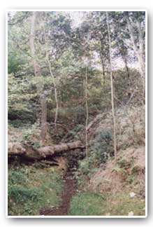
LANDSCAPE The altitude of the site rises from approximately 40 metres above sea level in the valley, to a high point of 110 metres on the wood's western boundary. Across much of the site, the land slopes gently to the east or north-east. However, the land is much steeper in the upper parts of the wood's central section where a landslip, probably dating from just after the end of the last Ice Age, has resulted in a small cliff with undulating land below. Such landslips are fairly common in rocks of this age, particularly in north Sheffield. In addition, near the northern end of the site, there is a steep sided valley known as 'The Ravine'. The only two major streams in Woolley Wood are located in 'The Ravine' and on the southern edge of the wood. There are also several smaller streams, which rise from springs within the wood and run for a short distance before disappearing below ground. The intermittent nature of these streams is a result of the underlying geology; the springs occurring where ground water meets an impervious layer of rock and the streams disappearing below ground again where more permeable rock is found. Not only are these streams intermittent in their course but they also tend to dry up in dry seasons. In addition to these streams, there are several marshy areas throughout the wood. Documentary and other evidence suggests that Woolley Wood, particularly in its lower parts, was once a much wetter habitat than it is today.
SOILS The soils on the most steeply sloping sites are shallow and freely drained and as a result have become acidic and low in fertility. Those at the foot of these slopes are deeper, less acidic and higher in fertility as a result of mineral salts washed down from above. The soils are further enriched along at least some of the stream courses where small amounts of alluvial deposits have built up.
VIEWPOINTS
|