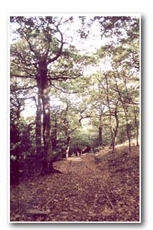
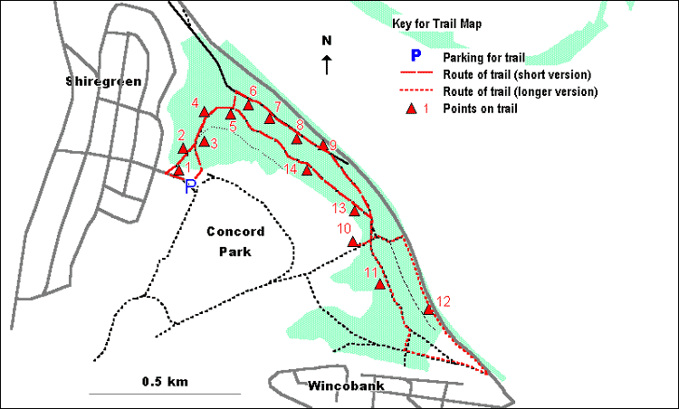
From the car park, follow the access road back towards the
gate and turn right down the path leading from the gate into the
wood. Stop at the woodland edge.
1. This is the highest point of the wood. In places there
is a dense shrub layer of Wild Cherry and Wych Elm and these two
species can be seen on the woodland edge. Wych Elm is distinguishable
by the asymmetric base to its leaves. Other trees visible at the
top edge of the wood include Sycamore, Ash and Oak.
Continue down the path into the wood.
2. The ground to your left slopes away steeply into 'The
Ravine', a stream valley in the northern part of Woolley Wood. Take
care as you walk along the edge of this steep slope.
Notice the way in which parts of this side of the valley have
been made very bare due to human activity (rope swings, etc) and
that this bare soil is starting to become eroded. The far side of
valley is far less accessible, both caused by and resulting in its
much denser vegetation.
The relatively inaccessible nature of the Ravine makes it of particular
value as a sanctuary area for wildlife.
Continue down the path and at the path junction turn left.
3. The area of Oak-dominated woodland to the right of the
path has been opened up by thinning of trees. This has had the effect
of letting in more light. Notice the way in which many of the stumps
of the felled Oak and Sycamore are now growing back vigorously from
their base.
As with other benches in Woolley Wood, that by the path at this
point is made of wood felled during woodland management work.
Take the stepped path down the slope, with the Ravine to your
left.
4. As you descend the path, to your left on the steep slope,
can be seen abundant Holly. In earlier times, Holly was often encouraged
to grow in woodlands and the foliage was then harvested as winter
feed for cattle.
As you move down the path, notice the way in which the roots of
large Beech tree on the slope to the right of the path have been
exposed by soil erosion.
To your left, on the slopes of the ravine, are a number of dead
Elms killed by Dutch Elm Disease. The lower parts of these trees
have been left as 'standing deadwood' in order to provide for the
fungi, insects and hole nesting birds which rely on dead and decaying
timber.
Carry on down the path to a path junction.
5. In common with other areas of Woolley Wood, this area
has abundant Yew trees. Yew is a relatively uncommon species in
woods in this part of the country. Note the way in which the dark
foliage of the Yew casts a dense shade, meaning that very little
grows on the ground beneath. In autumn and early winter, look for
the brightly coloured Yew berries. Although, in common with the
rest of the tree, these are poisonous to humans, birds can eat them
with no ill effect as they digest the soft red flesh, the poisonous
seed passing through their digestive system and being excreted.
Take the path to the left, down the steps. At the path junction
at the foot of the steps, turn right.
6. Being near the base of a slope, this is an area of woodland
on relatively damp soil. This is indicated by the presence of Alder,
a tree associated with wet places, which was once much more widespread
in Woolley Wood but which has now declined as a result of both drainage
and the clearance of woodland on the far side of Ecclesfield Road,
along the Blackburn Brook.
Also present here are large trees and smaller saplings of Ash,
a tree often characteristic of soils at the base of slopes which
have been enriched by nutrients washed down from above.
The ground flora here is tall and lush and includes wetland species
such as Valerian and Meadowsweet.
Continue along the wide, flat path.
7. This area is characterised by abundant clumps of ferns.
A clearing a short distance to the right of the path has a particularly
high concentration of these.
Continue along the path until you reach a small gulley containing
an intermittently flowing stream.
8. Trees in this area include Oak, Wild Cherry (distinguishable
by its shiny horizontally-banded bark), Ash and Sycamore. Elder
and Hazel are present in the shrub layer. The area also has abundant
fallen deadwood.
The ferns here do not grow in the characteristic clumps seen previously.
This is Bracken, which spreads easily by means of an underground
system of rhizomes.
Continue along the path until a blue TPT footpath sign.
9. The TPT sign refers to the Trans-Pennine Trail. This
is a coast-to-coast network of paths running from Liverpool to Hull
and which links to a chain of footpaths across Europe leading ultimately
to Istanbul! It has been constructed to be suitable for a wide variety
of users, including walkers, cyclists, horse-riders and people in
wheelchairs.
You will already have seen wooden barriers across the path. These
have been placed at regular intervals to deter people from bringing
motorbikes and other vehicles into the woodland.
Continue to a fork in the path where you should take the right
hand path. At the next path junction (marked by a bench and TPT
sign), take the wider path to the right until a further path junction.
If following the shorter version of this trail, turn sharp
right and take the path leading uphill. (Jump to point 13 on trail)
If following the full trail, carry straight on and, at a fork
in the path, turn right again, taking a path leading gently uphill.
Where a path running directly upslope crosses roughly at right angles,
turn up this for a short distance to the top edge of the wood.
10. Just inside the upper edge of the wood, set into a
bank, are the remains of a wall. This feature is likely to be the
remains of a wood bank, built to keep grazing animals from adjacent
farmland (now the golf course) out of the wood, thereby allowing
the growth of coppice and young trees. These walls were probably
demolished when the wood came into public ownership in 1925.
Retrace your steps back down to the point where the two
paths cross. Turn right and continue along the path through a wooden
barrier.
11. The southern end of Woolley Wood is, as a general rule,
more open than most of the areas seen so far. The upper layers of
the woodland are dominated by the introduced tree species, Sycamore
and Beech, with Oak and Elder at lower levels.
Continue along the path. At a fork in the path, take the right
hand path and then turn left at the path crossing near a bench.
Head down the wide path to the open space of Lower Wincobank Recreation
Ground. Continue across the recreation ground to Ecclesfield Road
where you should turn left. Continue along Ecclesfield Road for
some distance, taking care to stay on the pavement.
12. Note the way in which both the main road and the railway
line run parallel along the relatively flat land in the valley bottom.
Wooden barriers have been installed and long piles of old branches
placed where the woodland meets the road, in order to discourage
access and to deter dumping, which unfortunately takes place along
this stretch even now.
Continue along Ecclesfield Road until you reach a public footpath
sign indicating a path leading into the wood. Turn left here and
follow the path uphill. Ignore the first (sometimes muddy) path
to the right. Instead, turn right at the path crossing shortly afterwards
and retrace your steps along a short section of path walked earlier.
At the fork in the path, take the left hand path which leads
gently uphill.
13. A short distance up this path, immediately to the left
of the path, are further Yew trees and a patch of Wood Sorrel, which
can be distinguished by its 3-part, trefoil shaped leaves. Wood
Sorrel is one of many ancient woodland indicators found in Woolley
Wood, suggesting that the area has been wooded for at least the
past 400 years. Look for its white flowers in early spring before
the leaves of the tree canopy are fully developed.
Continue along the path, which can be muddy after wet weather.
14. The steep slope to the left of the path and the undulating
nature of the path itself are the result of landslips in the distant
past, probably just after the end of the last ice age when the ground
was still at least partly frozen.
Yew is a common species in this area and along with other trees
supports a particularly rich bird fauna, including a range of Tit
species. Look out too for Grey Squirrels which can be abundant here.
Carry on along the path for some distance until you reach
a path junction in an area of yew trees seen previously. Turn left
up the steps with the Ravine to your right and follow the path back
to the car park.