|
CLIFFE WOOD -
THE SITE
GEOLOGY
Cliffe Wood
is underlain by Coal Measures rocks dating from the Carboniferous period
of geological history. Sandstone is the dominant rock type, there being
small outcrops in a number of places across the site.
LANDSCAPE
Cliffe Wood lies on
a south facing valley side, just to the north of the River Dearne. The
altitude of the site ranges between approximately 35 and 75 metres above
sea level.
The River Dearne flows
in a generally easterly direction through Dearne Valley Park and forms
the southern boundary of Cliffe Wood in a number of places.
Cliffe Wood is bisected
by a long, flat grassy area on the route of a disused section of the Barnsley
Canal. The embankment of this can be quite high on its southern side and
this is particularly the case towards the eastern end of the site.
 |
|
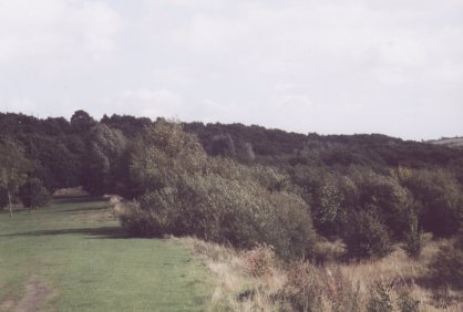
A view of Cliffe Wood from the old canal.
|
SOILS
Over much of the site,
the soils are acidic and free draining. In contrast, there is one area
of wetter soil, this being easily identifiable by the presence of Willow-dominated
woodland.
VIEWPOINTS
Being on a slope, the
site has a number of points giving views across the surrounding area.
Features visible from these viewpoints include the football ground, Barnsley
Town Hall, Barnsley Hospital and the disused pithead of Barnsley Main
Colliery, which provides a reminder of the valley's industrial past.
The best views can
be obtained from the top edge of the woodland along Rotherham Road and
from the eastern end of the old canal.
  
|

