CLIFFE WOOD
- A WOODLAND WALK
 |
|
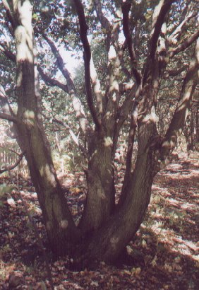
Cliffe Wood contains many multi-stemmed Oak trees that probably
date from the time when the woodland was coppiced. This
one is between points 7 and 8 on the walk.
|
The starting
point for this walk is the main parking area for Dearne Valley Park,
off Pontefract Road.
Alternatively the route can be joined at a number of other points
where it comes close to the perimeter of the site.
The walk is
just under 2.5 kilometres (roughly 1.5 miles) long.
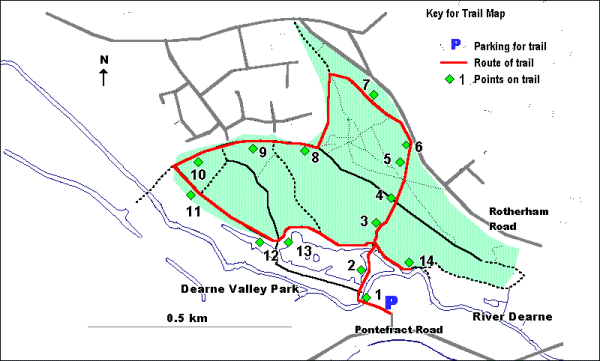
The route is illustrated on the map below.
Leave the
car park for Dearne Valley Park. The board at the entrance to the
park has useful information on the wildlife and history of Cliffe
Wood and the rest of Dearne Valley Park. Stop on the bridge over
the river.
1. You are now
crossing the River Dearne. Once, when Barnsley was dominated by
industries such as coal mining, this was one of the dirtiest rivers
in the region. Nowadays it is much cleaner and once again supports
species such as Brown Trout and Kingfisher.
Continue
along the path with the river on your right and the lake to your
left.
2. The shallow
water at the corner of the lake close to the path has been colonised
by Reedmace, with its characteristically shaped flower heads. These
are often, though mistakenly, called Bulrush.
Fish that live
in the small lakes of Dearne Valley Park include Carp, Perch, Bream
and Tench. Because of this, they are extensively used for angling.
Continue
along the path to the far edge of the lake and, keeping straight
on at the junction, enter Cliffe Wood.
3. You have
now entered an area of woodland dominated, like much of the rest
of the wood, by Oak and Birch. Find examples of these two trees
and consider their characteristics. As well as having differently
shaped leaves, the bark of the Oak is rough and greenish-brown in
colour whilst that of Birch is smooth and pale. What other tree
and shrub species can you identify here?
Continue
uphill through the woodland and then climb the steep bank leading
up to the old canal.
4. This long
thin strip of grassland is on the old route of the Barnsley Canal.
Note the way in which the route was made flat by building it on
an embankment on the side of the hill.
The grassland
divides into two types with short mown grass, mainly in the centre;
and uncut longer grass, mainly at the edges. The latter supports
a variety of other species including Bracken, Bramble and Wood Sage.
Continue
directly across the route of the old canal following the path into
another area of woodland. After climbing upwards for a short distance
you will reach a path junction. Continue onwards, directly uphill.
5. This area
of woodland is steeper than that seen previously and it becomes
progressively steeper as the upper edge of the woodland is approached.
It is this steepness of slope that leads to the woodland being named
Cliffe Wood. Steep slopes are common features of ancient woodlands
such as Cliffe Wood, other more accessible areas having been cleared
for agriculture.
Again Oak and
Birch are dominant, the latter increasing in dominance as the hill
is climbed. There is also abundant Hazel and a small amount of Holly.
Look at the shape of the trees in this area, noting the way in which
many of these are multi-stemmed.
Carry on
up the path until it emerges from the upper edge of the wood onto
a wide grassy verge on the edge of a road.
6. From this
point, there is a view across Barnsley, taking in (from left to
right) the old pit heap of Barnsley Main Colliery (now landscaped);
the football ground and Barnsley town centre (with the white tower
of the Town Hall being prominent).
Turn left
along the verge, with the road to your right. Just before the gate
onto the road, turn left down a path that slopes diagonally downhill
into the wood. Keep straight on, ignoring the first two paths off
to the left.
7. The area
to the right of the path consists of a mosaic of open, Oak-dominated
woodland; Bracken-dominated glades; and areas of multistemmed Hazel
coppice.
The Hazel coppice
is of particular interest, telling us about two periods of the woodland's
history. The present coppice dates from the early 1980's when trees
were cut for firewood during the miner's strike. The Hazel has now
grown back vigorously from its base to give a dense crop of straight
poles
This area also
gives a glimpse of what large areas of this and other local woodlands
would have been like for a long period of history when coppicing
was their main method of management. During this period, the poles
would have been cut at regular intervals, largely to be converted
into charcoal as a fuel for the early iron and steel industry.
When the
path reaches a fence at the edge of a new area of housing, turn
left and follow a path downhill through open, oak woodland, with
the fence to your right. At a gap in the fence leading into the
housing development, turn down a wide ride with woodland on either
side. At the bottom of this, turn right along the route of the old
canal.
8. This flat
grassy area on the route of the old canal has been planted with
scattered trees including Cherry, Willow, Oak, Field Maple and Horse
Chestnut.
Continue
for a short distance along the old canal with houses to your right.
9. To the left,
below the embankment formed by the old canal, can be seen the area
of woodland planted in the 1980's. This contains a greater variety
of tree species than the semi-natural woodland and is also more
open with the result that the ground flora is more grassy. This
area provides an ideal habitat for small birds and for mammals such
as Wood Mouse and Bank Vole.
Note the way
in which 'rides' have been left unplanted to give the area greater
variety and to provide woodland edge habitats which support a wide
variety of plant and animal species.
Looking back
along the old canal at this point provides a clear view of the sloping
area of Oak-Birch woodland, visited previously.
Continue
along the grassy route of the old canal
10. To the left
of the path, in a further area of Oak and Birch woodland can be
found an outcrop of the sandstone which underlays much of the site.
Note the way in which the colour of the sandstone changes once it
becomes exposed to the elements.
Continue
along the old canal but turn left into woodland before the bench
and the top of the steps.
11. This is
a good point to study the difference between the plantation woodland
(to the left of the path) and semi-natural woodland (to the right,
on the slope down to the river).
The plantation
woodland has a greater variety of species, including Oak, Ash, Hawthorn,
Hazel, Field Maple, Birch and Elder. The semi-natural woodland is
primarily dominated by Oak, with smaller quantities of Birch and
Hazel.
Look also at
the relative sizes and shapes of the trees in the two areas of woodland.
Those to the right of the path are larger and more twisted than
those on the left.
Continue
downhill along the path to the edge of the first small lake on the
right.
12. An area
of duckboarding here allows for close and relatively safe examination
of the pools and the life they support.
Waterbirds that
you might see in this area include Mallard, Coot, Moorhen, Little
Grebe, Great Crested Grebe and Canada Goose.
Continue
along the path, crossing another that leads across a causeway between
the two areas of water. Do not go across this, but carry on, keeping
the edge of the second lake to your right.
13. This point
provides a clear view across the larger of the two lakes towards
the disused pithead of Barnsley Main colliery.
Look at the
way in which the lake is fringed with Willow, Rushes, Great Reedmace
and Greater Willowherb.
Continue
along the water's edge to the far end of the lake. Where the path
leading from the car park joins from the right, continue straight
on for a short distance until you reach a Willow dominated area
on the banks of the River Dearne.
14. This area
of woodland on wet ground adjacent to the river is dominated by
Willow, a tree that unlike Oak and Birch is adapted to conditions
where the ground is at least partly waterlogged. This type of woodland
is known as carr. As well as Goat Willow, Crack Willow and Common
Sallow, other tree species in this area include Hawthorn, Sycamore
and Elder. The ground flora in this area is generally tall and lush
with Nettle, Bittersweet, Bindweed, Burdock, the introduced species,
Himalayan Balsam, and an abundance of Hemlock Water-dropwort, a
rare plant in the Barnsley area.
Retrace your
steps to the path junction and then turn left and back across the
River Dearne to the car park.
  
|