|
HAIL MARY HILL
& FALCONER WOODS - THE SITE
GEOLOGY
Hail Mary Hill and Falconer Woods are underlain by Middle Coal Measures
rocks dating from the Carboniferous period of geological history. These
consist of alternating layers of shales and of Mexborough Rock, a sandstone.
The latter has a characteristic reddish tinge and has been used in the
construction of a number of significant buildings in the centre of Rotherham,
including the Parish Church.
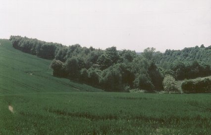 |
|
The northern
end of Hail Mary Hill Wood showing the valley of Treeton Brook.
|
LANDSCAPE
Hail Mary Hill and Falconer
Woods lie on the east side of the valley of the River Rother. The
highest point, at the south-west corner of Falconer Wood is at about 80
metres above sea level. From here, the woodlands slope quite steeply down
to the shore of Treeton Dyke.
Hail
Mary Hill and Falconer Woods face mainly south westwards, although the
northern limb of Hail Mary Hill Wood slopes northwards towards Treeton
Brook. This stream
runs through the northern edge of Hail Mary Hill Wood before spreading
out to form Treeton Marsh and entering the open water area of Treeton
Dyke. A
number of springs run from the top of Falconer Wood down the slope towards
Treeton Dyke.
The open water area of Treeton
Dyke is artificial. It is situated over the original course of the River
Rother, which was diverted in around 1840 to stabilise land for the building
of the Midland Railway. The water of the cut-off produced was impounded
in the late 1930's or 40's to provide water for Orgreave Colliery and
it is this that now forms Treeton Dyke. The former Orgreave Colliery Tip
on the far side is now being opencasted but, following this, will be restored
as an area of open space.
SOILS
The soils underlying the woodland
are acid brown earths with a pH ranging from 3.5 to 5.0. In some areas
these can become waterlogged. Along
the streams are narrow strips of finer textured alluvial soils containing
clay and silt.
VIEWPOINTS
The area of acid grassland above
Hail Mary Hill Wood offers extensive views northwards along the Rother
Valley towards Rotherham, north-eastern parts of Sheffield and beyond.
Treeton Wood is easily visible, a short distance
away across fields. Canklow Wood, another
of the Heritage Woodlands can also be seen, about two miles to the north.
The path along the
shore of Treeton Dyke provides interesting views to the opencasting work
on the old Orgreave Colliery tip.
  
|

