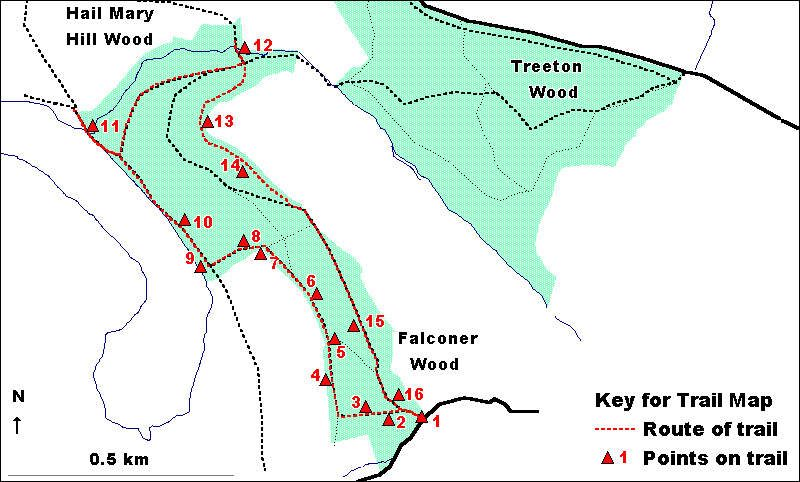
|
HAIL MARY
HILL & FALCONER WOODS - A SHORT TRAIL
The starting point for
this trail is the gate at the eastern corner of Falconer Wood. This
leads off Smallage Lane, which can be approached from either Fence
or Aughton (via West Lane). For groups approaching the woodland
from other directions, the trail could be picked up at a number
of other points, including from Treeton (points 12 and 13 on the
trail).
The trail is
2.75 kilometres (just over 1.6 miles) long. The majority is surfaced
and easily accessible, following the bridle route through the woods.
The section leading up to the viewpoint on Hail Mary Hill is steeper
and has steps. An alternative would be to follow the bridle route
below Hail Mary Hill.
The trail route
is illustrated on the map below.
Enter Falconer Wood
through the gate off Smallage Lane
1. There are
two different types of 'gate' here, designed to let through different
users of the woodland. A gate here has to be able to let through
horses but not cars.
Turn immediately
left along the lower bridlepath noticing the large Oak tree at the
path junction.
2. This area,
under a line of pylons, shows what happens when an area of woodland
is felled and then allowed to grow back. The trees have been felled
so as not to touch the electricity wires. Just because trees are
cut back, even to their base, does not necessarily mean that they
are killed. This was the principle behind coppicing, an ancient
and once widespread method of woodland management.
Continue
down the bridlepath for a short distance.
3. Emerge from the dense area of young trees under the power lines
into an area of more open woodland and compare to the area under
the power lines that you have just left. Birch and Oak are the dominant
trees in both areas but this area is much more open with the trees
being generally older, taller and further apart and with the woodland
floor dominated by grass with Bracken, Brambles and Bluebells.
Falconer Farm
is visible through the trees to the left. This ancient farm is thought
to derive its name from Robert de Faulkener, a fourteenth century
Norman lord and landowner in the parish of Aston-cum-Aughton.
Carry
on down the bridlepath, ignoring the footpath off to the right.
At the 'T-junction' near the lower woodland edge turn right.
4. You have
now reached the lower woodland edge. Notice the way in which, because
more light is able to penetrate at the woodland edge, the woodland
floor supports a wide range of flower species, including Bluebell,
Red Campion, Greater Stitchwort and Buttercup.
5. This area
of bare soil is the result of bicycle and motorbike riding. To what
extent is the damage to this small area of woodland acceptable or
unacceptable. What could be done to prevent it?
6. Here the
Oak and Birch trees are relatively young, with straight, narrow
trunks. This is because this area of woodland has been felled and
then grown back in the relatively recent past.
7. At this point
you pass from Falconer Wood into Hail Mary Hill Wood and the path
cuts through a small open area on the edge of the woodland. On a
sunny day in spring or summer, this is an excellent place to see
butterflies which live both in the fields and on the woodland edge.
Listen also to the variety of birds which favour this 'edge habitat'
more than they do the centre of the woods.
Along the edge
of Hail Mary Hill Wood, leading down to Treeton Dyke is an old overgrown
Hawthorn hedge.
8. Just inside
the woodland is a strip of damper, nutrient enriched ground. This,
in association with the increased light coming from the woodland
edge, has resulted in a wide range of ground flora plants including
abundant Bluebells and Ramsons (wild garlic) which should smell
strongly in late spring.
Follow
the bridlepath down through the woodland to the edge of Treeton
Dyke.
9. Treeton Dyke
is artificial, resulting from the diversion of the River Rother
in order to stabilise land for the building of the Midland Railway.
The lake was then used to provide water for Orgreave Colliery. Now
that this use has ceased, the water is used for variety of uses
including fishing, water skiing, and as a nature reserve.
Look across
Treeton Dyke to the opencast coal workings beyond on the former
Orgreave Colliery Tip. Following opencasting, this area will be
restored. Notice how less disturbed areas of the old tip are already
being colonised by trees.
Turn right
along the path parallel to the water's edge.
10. The path
follows an electricity line where again the trees have been felled
to avoid them touching the wires. Notice how the shrubs and trees
have grown back vigorously along the edge of the path. This previously
cleared area is now attractive to birds, butterflies and other insects,
again showing that the felling of trees is not always a bad thing
for wildlife.
At the
path junction, follow the concrete path onto the bridge across Treeton
Marsh.
11. Notice how
as you move into and across Treeton Marsh, the woodland gives way
to Willow 'carr' and then to Reeds and other wetland vegetation
surrounding pools of open water. In late spring and summer, listen
for the chattering sound of Warblers in the reeds.
Treeton Marsh
is a good example of the natural process known as 'succession'.
It was once much more open with large pools of water. As Reeds and
other wetland vegetation colonised the open water, the area of this
was reduced. These plants trapped silt brought down by the stream
flowing into the area and this, together with the remains of the
plants as they died, gradually filled in the areas of water. After
this process had continued for some time, the ground became sufficiently
dry for Willow to spread in and form 'carr' woodland. If this process
is allowed to continue, Treeton Marsh will eventually dry out and
become woodland.
Return
to the path junction and turn left, again following the bridlepath.
Continue straight on where the bridlepath turns back on itself and
goes uphill (unless following the alternative route). Where the
paths cross, turn left and walk to the dead tree by Treeton Brook.
12. Associated
with Treeton Brook is wet woodland containing a wide variety of
trees and shrubs, including Ash, Hazel, Guelder Rose, Alder, Willow,
Elm, Sycamore, Oak, Dog Rose, Field Maple, Crab Apple and Rowan.
The ground flora of this area is also rich, with Lesser Celandine,
Meadowsweet, Red Campion and Angelica, and the ancient woodland
indicator species, Yellow Archangel, Dog's Mercury, Wood Sorrel,
Moschatel, Ramsons, Yellow Pimpernel, Wood Anemone, Greater Stitchwort
and Opposite-leaved Golden-saxifrage.
The dead tree
near the stream shows evidence of 'attack' by a variety of creatures.
The small holes are caused by Woodworm and the larger ones by Woodpeckers
searching for insects and their larvae. All over the trunk are patterns
carved by beetle larvae at a time when the tree still had bark.
The tree is almost certainly the remains of an elm killed by Dutch
Elm Disease.
Retrace
your steps to the path junction and continue straight on up the
wooden steps. Keep straight on up the path to the top of Hail Mary
Hill.
13. The top
of Hail Mary Hill has a small area of acid grassland. Look at how
the edges of the area are being colonised by Bracken and then by
young Oak and Birch trees. This is another example of the process
of 'succession'. If the process is allowed to continue, the top
of Hail Mary Hill will ultimately become woodland.
The top of Hail
Mary Hill provides extensive views northwards along the Rother Valley,
past the top of Treeton church tower, to the edge of Rotherham.
Canklow Wood, another Heritage Woodland, can be clearly seen, about
two miles to the north. To the west can be seen Treeton Dyke and
the opencast coal workings, and beyond these, the edge of Sheffield.
To the east, across fields, is Treeton Wood, another Heritage Woodland.
Note the way in which this too is intersected by electricity lines.
Just below the
crest of Hail Mary Hill is an archaeological site dating from the
Middle Stone Age. Here hard stones such as flint, were fashioned
into tools used for a variety of purposes. A pottery fragment of
Roman age has also been found on the highest point of the hill.
From Hail
Mary Hill continue southwards along the path, with a fence to your
left
14. Look down
the slope into the centre of the woodland. Again, this is dry, acid
woodland dominated by Oak and Birch. Use the viewpoint to imagine
what it would be like to live in the treetops.
Continue
southwards along the path and down the steps and turn left to rejoin
the bridleway.
15. Look at
the pylon. Notice the way in which it is constructed out of triangles
because these are a particularly strong shape.
16. The field
above the wood at this point usually contains horses. The grazing
of horses, sometimes known as 'horsiculture' is a common land use
on farmland close to urban areas. This is because there is much
demand for horse grazing from people living in the towns and also
because conventional agriculture is often uneconomic in such areas.
Leave
Falconer Wood through the gate onto the lane.
  
|